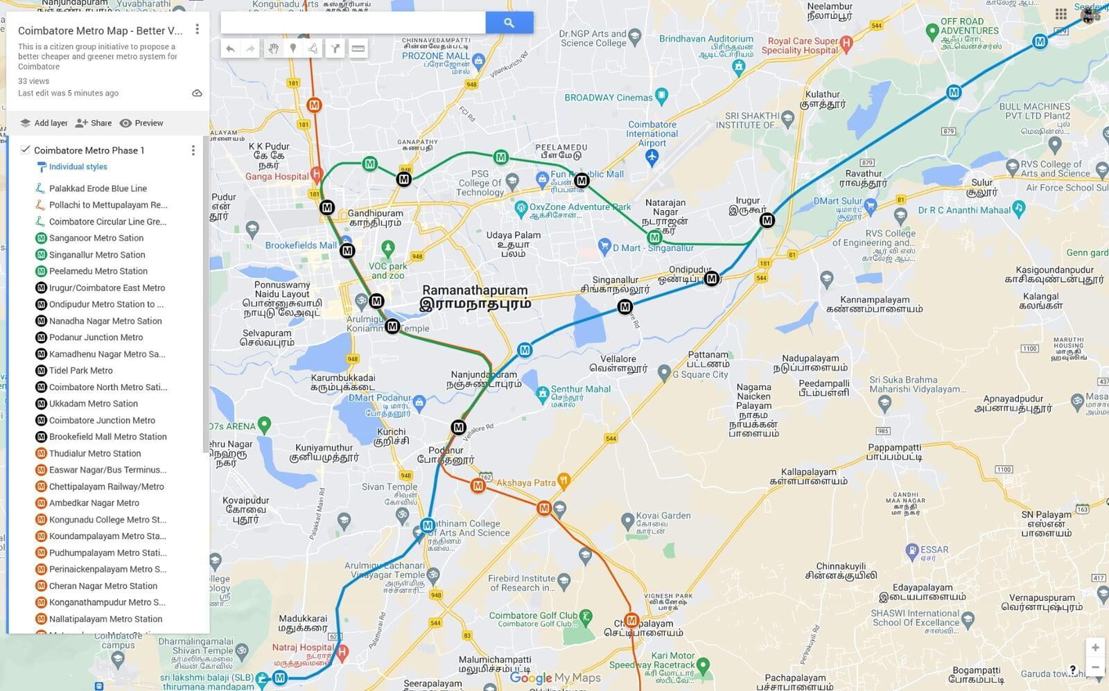
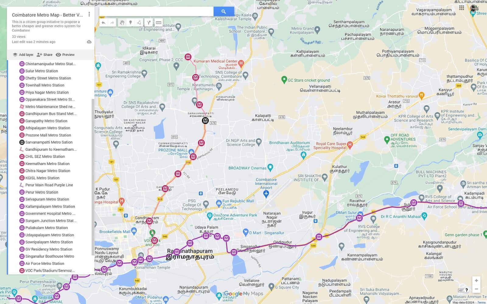
Here is our version of a more sustainable, cheaper, faster (to build) metro system for the city of Coimbatore.
Coimbatore city is set to have its first mass transit system, as the Tamil Nadu government has approved the construction of phase 1 of the metro project with a budget of ₹9000 crore. The project faces some challenges in its execution and alignment, but it is a positive sign of progress for the city. We do not want to dwell too much on the current plans as most of the information is available online on Metrorailnews. But what we really want to talk about is how creating a mass rapid transit system like a metro is a wonderful opportunity to change the dynamic of a city. With such generous funding being allocated to these projects, it is also an opportunity to rectify past mistakes in city planning and promote more equitable development throughout the city.
The Problem
Despite the significant investment in metro systems across India, they have failed to bring about equitable development or create new growth areas. This is due to a quick-fix approach to traffic problems, which has resulted in the planning of metro routes along arterial roads that are already well-developed, have excellent bus transport, are quite wide in most cases, and have unaffordable property prices. To promote more equitable development, it is essential to adopt a more comprehensive approach to city planning that takes into account the needs of all citizens and communities. Running a metro through these well-developed arterial roads creates the following developmental issues:
- Concentration of Development: The metro line running along the same route creates even more demand, further concentrating all development along the same arterial road exacerbating the problem of inequitable development.
- Further inequality in the real estate opportunity: Large organisations and wealthy individuals already own land on these high growth corridors, a metro line further adds to their kitty and completely prices out the common man.
- Nothing changes in the city dynamic: the metro system simply reduces the traffic marginally for a few years until new vehicles takeover the remaining road space. The metro system further increases density along these roads as no new growth area has been created.
- Already developed roads: These roads already have many flyovers, pedestrian spaces and bus stops leaving no room for an additional transit system causing huge land acquisition costs and massive disruptions for many years on main arteries of the city while the metro is under construction.
- Too Expensive: By spending fraction of the cost, most of these arterial roads are well placed to be easily upgraded to Bus Rapid Transit Systems, dedicated cycling paths, more organised parking and pedestrian facilities.
- Too much centralisation: The current metro route map follows the hub and spoke model where it requires a commuter to reach one of the central stations to change his/her line to travel in a different direction. There is nothing going sideways causing vast populations to not enjoy the benefit of the Metro System. Hub and spoke model does not work in cities that do not have a central business district.
- Tiruppur to Madukarai Blue Line (extendable to Erode)
- Mettupalayam to Pollachi Red Line (extendable to Udumalpettai)
- Irugur to Podanur Coimbatore City Circular Green line. (extendable on either side)
- Kalampalayam (Siruvani Main Road) to Karnampettai (Trichy Road) Purple Line.
- Coimbatore Railway Junction to Keernatham (Sathy Road and CHIL IT SEZ Road) Pink Line.
- Vellalore to Kovilpalayam (Vilankurichi road and Sathy Road) Brown line.
- Vellalore to Kunuvai (Sanganoor Stream and Thadagam Road) Turquoise Line.
While we acknowledge that no solution is perfect, we are well aware that we may have missed a few practical issues that could arise with our proposed solution. We may have knowingly or unknowingly skipped a few important corridors from the transit system. To address this, we have activated the comments section to gather feedback and further improve the plan until it can be presented to the right authority that can incorporate some of these suggestions. Our goal is to make the Coimbatore Metro the most cost-effective, environmentally sustainable, and socially responsible metro system in the country.
The Overarching Goals of the Proposed Solution
- The metro must be much cheaper to build compared to conventional metro system, and the excess funds must be used to improve pedestrianisation, bus system and introduce cycling as a viable transportation method around the city.
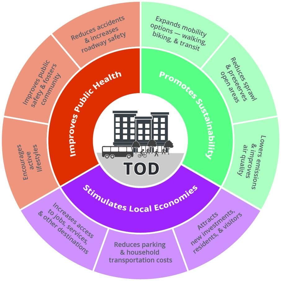
- The system must bring about transit-oriented development and must gradually shift part of the new developments closer to the metro system, overtime decongesting the arterial roads.
- At the risk of limited early-stage demand, the metro must be operated on densely populated but at the same time under-developed areas such that these areas can become new growth centers of the city.
- The route map must traverse through middle income and low-income neighbourhoods so that people living in these areas can participate in the real estate opportunity that a new transit system brings about.
- The route map must complement but at the same time avoid running on the three arterial roads, Avinashi road, Mettupalayam Road and Trichy Road as these roads have sufficient scope for improved road transportation through flyovers, lane expansion, bus connectivity and cycling paths.
- The route map must bring about positive environmental change in the city through improved cleanliness and incorporating green features in Metro Stations. Further, our plan for the Turquoise line is to run it mostly on the Sanganoor Stream which will help revive a dead stream and make it a vibrant hot spot for the citizens.
- The city must slow down its growth on the Environmentally sensitive Western side. While enough damage has already been done to the foothills due to poor planning, we limited the connectivity on the Western suburbs and increased it on the East and South to slow the pace of growth in sensitive eco zones.
- Almost the entire metro system must run above ground to reduce construction costs and perhaps more crucially reduce the operational costs by avoiding artificial lighting and ventilation systems the underground systems require.
- Since Coimbatore does not have a Central Business District, the city must follow a hybrid model that combines elements of both the hub and spoke and the circular models of mass transit.
We will give our clear recommendations to achieve the above goals the sections below. If the above points are clear, let's move on to phase - 1 of the Coimbatore Metro Route Proposal - the better version.
Coimbatore Metro Phase 1 - Use the existing railway infrastructure around the city
The phase 1 proposal of the Coimbatore Metro has three lines, the Tiruppur to Madukarai Blue Line, the Mettupalayam to Pollachi Red Line and the Irugur to Podanur Coimbatore City Circular Green line. This phase is one of the most important phases in achieving some of the primary goals of the project which is to reduce costs through utilisation of existing infrastructure by improving it and expanding it. All three lines on this phase use the existing railway lines running around the Coimbatore District. This essentially is an MRTS system but for the sake of this proposal and ensure uniformity of terms used we will call it the Metro.
This is also the most challenging phase of the proposal as most of the areas around the existing suburban railway station are quite underdeveloped and creating the required demand will require interventions from different government agencies. There is also the challenge of the lack of sufficient railway lines to handle the additional load, issues around ticketing and user compliance, safety and security. There could be other operational issues that we did not anticipate in our research but might have been the reasons why this seemingly straight forward project has not taken off earlier.
Here are some ideas that attempt to address the issues highlighted above:
- Underdeveloped Stations: All the existing stations will have to be improved at meagre costs. In the initial stages, maybe just the basics like toilets, lighting, CCTV, pedestrian access, all weather roof, roads leading to these stations and ensuring every single station has a bus stop right outside to provide further connectivity. Most other aspects are already in place at most of the existing stations. New stations have been proposed on these lines at important road junctions to improve connectivity with the existing arterial roads.
Focus on NMT (Non-Motorized Transport): Dedicate a significant portion of the "excess funds" (saved from not building an expensive elevated metro on arterial roads) to building 5-foot-wide, shaded, and well-lit cycle tracks and pedestrian paths connecting a 1 km radius around all MRTS stations. Encourage cycling and walking to/from the station.
Dedicated EV/Share-Ride Hubs: Ensure every station plaza has a designated, covered, and highly visible parking area for shared auto-rickshaws, city buses, and future electric vehicle (EV) shuttle services, separate from regular traffic.
 Tidal Park Metro Access to Tidal Park and Avinashi Road Hopes College area. Here buses can be boarded to access the entire Avinashi Road stretch. | Kamadhenu Nagar Metro Located just below the Textool bridge to access Gandhipuram, OMNI bus Stand and the Entire stretch of Sathy Road. | Sanganoor Metro Access to densely populated Sanganoor main Road and surrounding areas. | Ukkadam Metro Located on sungam bypass road just below the railway bridge, it provides walkable access to Ukkadam Central Bus Stand. | Brookfield Mall Metro |
- New Stations on Red Line: We have proposed TEN new metro stations in the red line. Since this is the longest line on the system, these stations have been proposed in order to reduce the distances between stations and to provide more areas with access to the metro system. It must also be noted that all the stations proposed are at a junction of a key district road or the station is very close to the national highway such that commuters can have quick access to the bus services on the national highway or can easily get to their workplace or educational institutions.
Bilichi Metro Access to Bilichi and within 300 Mts of Mathampalayam bus stop on Mettupalayam Road | Pudhupalayam Metro Located at Pudupalayam Rakipalayam road junction with access to Pudhumapalaym main road and Idigarai. | Udayampalayam Metro Located on Udayampalayam road next to GN mills Rail gate with access to Udayampalam and Mettupalayam road with 600 Mts | Koundampalayam Metro Located on Nallampalayam road just below the railway bridge provides access to Koundampalayam and Nallampayama Areas. | Mettupalayam Road Bus Stand Metro Located right behind the bus stand will become part of the same campus to allow quick access to Nilgiris bound buses. |
 Eashwar Nagar Metro Access to the new Coimbatore Integrated Bus Station and high density areas on Chettipalayam Road | Ambedkar Nagar Metro Access to the L&T Bypass and the upcoming developments on the Bypass Road | Nallatipalayam Metro Station Line runs very close to Pollachi Main Road giving access to all nearby areas. | Konganathampudur Metro Station Line runs very close to the highway giving an opportunity a setup a station very close to the busy highway. | Cheran Nagar Metro |
- New Stations on Blue Line: We have proposed FIVE new metro stations in the blue line. Since this is expected to be one of busiest line on the Phase 1 of the system, these stations have been proposed in order to reduce the distances between stations and provide more areas access to the metro system. It must also be noted that all the stations proposed are at a junction of a key district road or the station is very close to the well-developed national highway such that commuters can have quick access to the bus services on the national highway. This line can be extended to Erode and Palakkad on either direction provided dedicated rail lines area installed and disturbances to the wildlife can be avoided on the Palakkad line. In the entire phase 1 Podanur/Coimbatore South is the common station for all the three lines. Since it is an underutilised asset there is potential to make it a hub for the Phase 1 of the system and maybe bring about rapid growth in and around this perennially underdeveloped area.
Rasipalayam Metro Access to Arasur and Rasipalayam areas adjacent to Avinashi road. This station was added to cater to the indutrial cluster in the area. | Ondipudur Metro Located just below the ondipudur flyover at Trichy Road junction with access to Trichy road via local buses and Ondipudur and Singanallur Areas. | Nandha Nagar Metro Located on Vellalore road below the Rail bridge with access to Vellalore and Singanallur junction road within 800 Mts | Nanjundapuram Metro This station has been added on a relatively un developed area at Nataraja Mill Road. It gives access to Trichy Road junction within 2 Kms. | Sundarapuram Metro Located just below the flyover on Pollachi Main road, it gives access to Pollachi road and multiple educational institutions on the stretch |
- Transit Oriented Development: Given our larger goal of creating equitable development in the city, such a plan would require government support at the highest level to ensure that some of the new development is pushed towards the metro stations and away from national highways. Even before the work begins on creating the infrastructure, the government must announce a higher Floor Space Index for all developments within an 800-meter radius of the metro stations. The incentive could be along the lines of
- 10% additional FSI for developments close to urban stations.
- 20% additional FSI for developments close to suburban stations.
- Reduce the number of buses serving Tirupur, Mettupalayam and Pollachi routes and encourage the public to shift towards the much greener and safer Metro Transit system. This will reduce the traffic on these roads and the buses can be diverted to serve areas with poor bus connectivity.
- If possible, relocate the Food Corporation of India Godowns in Coimbatore North and Peelamedu to stations at the outskirts of the city and open up the space for high density commercial and residential developments.
- Explore possibilities of redevelopment of defunct mill land on both sides of the Brooke Bond road as these have potential to increase density in areas which are within 800 mts of Coimbatore Junction and Brookefield Mall Station.
- Train Timings and Initial Infrastructure: The success of phase 1 of the project hinges on the punctuality and regularity of the trains. Regardless of demand, the trains must run on a highly regular interval. On the longer blue and red lines, trains should be available every 30 to 45 minutes without exception. On the Green Circular line, which is likely to be busy at most times, trains must run every 15 - 20 minutes on all days except weekends and holidays. By ensuring that the trains run on time and are available at regular intervals, we can provide a reliable and efficient mode of transportation for the people of Coimbatore. To achieve all the above, the southern railways might have to take the following steps:
- According to our estimate only 3 trains on the green line, 4 trains on the blue line and 5 trains on the red line will be required to achieve this frequency without counting breakdowns.
- The trains must operate in two worker shifts i.e. from 6 am to 10 pm.
- Divert most Kerela bound trains from Podanur straight to Tiruppur and vice versa to decongest the Circular line and the Coimbatore Junction.
- Privatise the entire Metro system operations either to CMRL or to a private entity on a revenue share arrangement such that these operations are not hindered by any in efficiencies on the Railway side.
- Build at-least one additional dedicated rail line on the Green Circular line and the Blue Line to ensure these routes operate without affecting the long distance trains.
- Operate the trains with no more than 3 to 5 non-AC coaches in the early phase. Focus should be on providing higher frequency instead of higher capacity. Do not separate ladies and gents' coaches but do provide an open space in one of the coach's for differently abled persons and cyclists encouraging them to bring their cycles along.
- To ensure that the metro system is efficient and effective, the trains must have a fast pick-up and brake feature and operate at an average speed of at least 60 km/hour. Please note that this has to be the average speed and not the top speed, as anything slower will move people back to road transport. The upcoming Vande Metro is likely to be best suited for this purpose, as it is designed to provide faster commuting for shorter distances at speeds of up to 130 kmph.
- The timings must be synchronised such that anyone travelling from Tiruppur via Irugur, Mettupalayam via Coimbatore North or Pollachi via Podanur into the city must have a green line train waiting for them to board without any delay so that they can proceed into the city immediately. This is very critical step as any mis match here will again encourage commuters to shift to road transport.
- Provide last mile connectivity at every station with meagre parking, a bus stand and auto stand.
- Provide a shuttle bus service at Irugur Metro to connect to the upcoming airport terminal building on the Irugur side of the runway at Coimbatore Airport.
- Ticketing, Pricing and ensuring user compliance: To ensure that the metro system is accessible and affordable, Phase 1 must have a simple pricing structure of Rs. 1/km traveled, with the minimum pricing fixed at Rs. 10 and the maximum pricing at Rs. 60. This means that anyone traveling all the way from Mettupalayam to Pollachi will pay a meager Rs. 60 only. In the future, if there is a demand, an additional 1st class AC coach can be added at 2X the regular pricing. These rates are the bare minimum, and the only way the system can operate with at least a minimum profit is to ensure 100% ticket compliance. By keeping the pricing structure simple and affordable, we can encourage more people to use the metro system. To ensure this the following steps maybe taken.
- There should be no subsidies, no freebies and differential treatment based on gender or age except cyclists must be allowed to bring their cycles free of cost and registered differently abled can travel for free.
- The entire ticket vending process and train cleaning process must be fully privatised to a ticket vendor company, where the company gets a fixed amount per ticket sold, say Rs.2 per ticket or maybe 10% of total fare collected. Different companies must be given contracts for different lines.
- Since there is an incentive for ensuring ticket compliance the private company will deploy the required number of personnel to ensure 100% compliance. Additional incentives can be given for cleanliness.
- The tickets must be sold inside the coach itself just like how it is done through conventional bus conductor system. The ticket vendor will be trained to handle rouge elements and will be in charge of safety and security of the commuters. This ensures no additional security personnel need to be deployed and no infrastructure needs to be created on the platforms for ticketing.
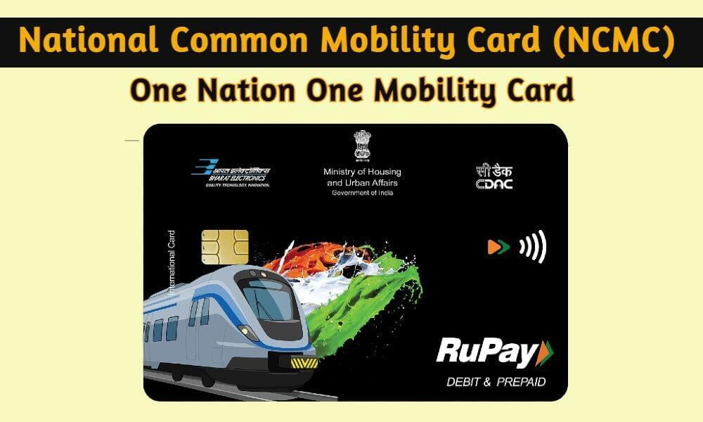
- The ticketing along with the TNSTC buses must be brought into a single transit card system like the proposed National Common Mobility Card. The ticket vendors will carry the required RFID reader for scanning the card.
- Just as every other metro system, additional revenue could be generated through advertisements, food stalls at stations and film shooting fees.
- Day passes could be issued at ₹120/day or monthly passes can be sold at ₹2000/month. These passes must provide unlimited free travel in all metro and bus systems in the city within the validity period.
Coimbatore Metro Phase 2 - Connect two critical corridors through completely overground route
Phase 2 of the Coimbatore Metro system is completely above ground and can be constructed while Phase 1 is being developed. Alternatively, one could wait and watch the response to Phase 1 before starting Phase 2 works. Phase 2 has two lines: the Pink Line from Coimbatore Railway Junction to Keerantham Village and the Purple Line from Kalampalayam on Siruvani Main Road to Karnampettai on Trichy Road. This line runs through some of the busiest parts of the city and intersects at the Coimbatore Junction.
Unlike Phase 1, Phase 2 does not have challenges around creating demand, as there is already huge commuter traffic on these routes. The biggest challenge here is to create the infrastructure above ground without causing disruptions or problems around land/space availability while keeping costs extremely low, such that the Coimbatore Metro is the cheapest metro system per kilometer in the country. Staying true to our early goals of the project, we have avoided arterial roads to the extent possible and chosen high-density semi-commercial and residential areas for parts of the route plan. We do anticipate some challenges around executing the corridor in narrow roads around Sowripalayam, Vysial Street, and Keernatham. There are additional challenges like crossing the Gandhipuram Flyover and the Trichy Road flyover, which will have to be solved at the time of project planning.
Here are some of the ideas that attempt to address the issues highlighted above:
- The Pink line: The pink line starting from Coimbatore Junction and going up to Keernatham village is quite likely going to be the busiest route in the entire Coimbatore Metro System as it connects the Coimbatore Junction with Gandhipuram Central Bus stand further providing connectivity to the IT corridor along the Sathy road and passing through KGISL and CHIL IT SEZ where more than 100000 people go to work on any given day finally ending at Keernatham village. Our proposed route is in fact not too different from the current proposal of running a metro line on the Sathy road and we agree with it as there is genuine lack of infrastructure on this road and there is limited space for expansion unlike the other arterial roads. Our proposal differs slightly as it avoids the Nanjappa road instead uses the park gate road. The metro will travel through the Senmozhi Poonga giving a great view of the parks below to the commuters and then proceeds to the Saravanampatti Junction. Here again we have made a slight change where the line detours into the Keernatham CHIL IT SEZ road. With 3 major IT parks on this road and a lot more under construction, the metro through this road will be a lot more beneficial at the early stage.
- The Purple Line: The purple line being one of the longest above ground lines is likely to be the most challenging to execute as it traverses through some of the narrowest internal roads before opening onto the highway. Staying true to our primary goals this line avoids Trichy road and the Sungam flyover to the extent possible and instead goes through the more densely populated areas of Udayampalayam and Sowripalaym before joining back on Trichy Road at the Perks Arch. The line will require some land acquisition and some adjustments to how the roads below will be used in the future as some roads in the route on Vysial Street, Selvapuram, Udayampalayam, Sowripalayam are heavily encroached and have very limited width. Some of these roads will have to be expanded on either sides and maybe at some locations completely pedestrianised by providing alternate routes for vehicles.
- Keeping the Costs Extremely Low: One of the key features of this phase and the next phase is to keep the cost per km of the system to be one of the lowest in the country. The aim is to be operationally profitable from day one through minimal maintenance requirements at stations. Here are some of the steps that could be taken in order to keep capital and operational costs to the minimum:
- The entire network must run above ground and any challenges that come about due to lack of space must be addressed through land acquisition. In most scenarios, simply being aggressive towards removing every small encroachment creates more space that on can envisage.
- If some roads are losing driving space due to the Metro pillars these must be made one way or pedestrianised. Alternate routes can be developed to make up for the lost space.
- Every station must be green building certified such that every drop of water that falls on the roof is harvested purified and reused for the station daily needs, all the roof must be solar ready to ensure net zero station operations. All stations must be semi open spaces allowing ample daylight and ventilation.
- All metro stations have 3 levels, the road level, the concourse level and the platform level. The station must be simplified to fully eliminate the concourse level such that commuters just climb one floor to reach the platform and board the train. CMRL has implemented this concept in the Phase 2 of the Chennai Metro.
- Concourse levels may be required only for some stations that have a line interchange.
- Standardise station designs to such an extent that every station can be built in no more than two months each using Precast base structure with a simple Pre-Engineered steel frame to provide the roof and side wall finishes.
- The precast base structure must come with prefinished polished concrete floors and staircase so that all forms of tiling or granites and associated installation delays, wear and tear issues can be avoided.
- The roofing can be made of Building Integrated Photovoltaics so that all station operations can run on solar energy from day 1 itself.
- All toilets must be plug and play where a module comes in and gets fitted into the Pre-existing water supply and sewage conveyance system. After sufficient use the module is sent for recycling and a new one is fitted in its place.
- Avoid using expensive equipment like escalators and travelators. Every station must be equipped with a large passenger lift that takes passengers directly from road level to platform level. Users must be made to understand the health benefits of using the stairs, active building standards must be followed to make using the stairs more appealing.
- Automate using AI and randomise the security checks to avoid baggage and commuter scanning for every single passenger.
- Spaces for advertisements must be pre-designed into the station design so that ad revenue can be earned as soon as operations start.
- Trains, Timing, Ticketing and Initial Infrastructure: Most of these aspects have been elaborated on the Phase 1 plans, while the system type is different for Phase 1 compared to Phase 2 and Phase 3, the ticketing, pricing and timings have to be standardised. Here are some steps that could be taken to ensure the system works seamlessly:
- Unlike Phase 1 ticketing can go back to conventional metro style ticketing where a barricade must be crossed after scanning the ticket. If a person gets on at Phase 1 Line and buys a ticket to get off at a Phase 2 station, the ticket bar code can be scanned to enter and exit the Phase 2 station.
- If the opposite were to happen where a person gets on at Phase 2 station and wants to get off at a Phase 1 Station. He/she can simply produce the ticket to the ticket vendor on the train to be scanned for authenticity.
- The ticket vendor gets his sales commission for simply the act of scanning a valid ticket. Every ticket automatically expires after a certain time duration to avoid misuse.
- By the time the Phase 2 is operational most people will be very comfortable using mobile tickets bought through apps like PayTM or Universal travel cards. Physical ticketing must be discouraged to the extent possible in Phase 2 and Phase 3 to keep personnel costs low.
- Phase 1 uses railway infrastructure and Phase 2 uses street level metro infrastructure, there is likely to be some distance to walk at interchange stations like the Coimbatore Junction, Tidal Park Station, Coimbatore North Station etc. Seamless walking paths and foot overbridges must be provided to ensure smooth transition between the lines.
- All trains on the Phase 2 and Phase 3 of the network must be driverless trains to avoid any human error or delays due to staff shortage and more importantly to future proof the system.
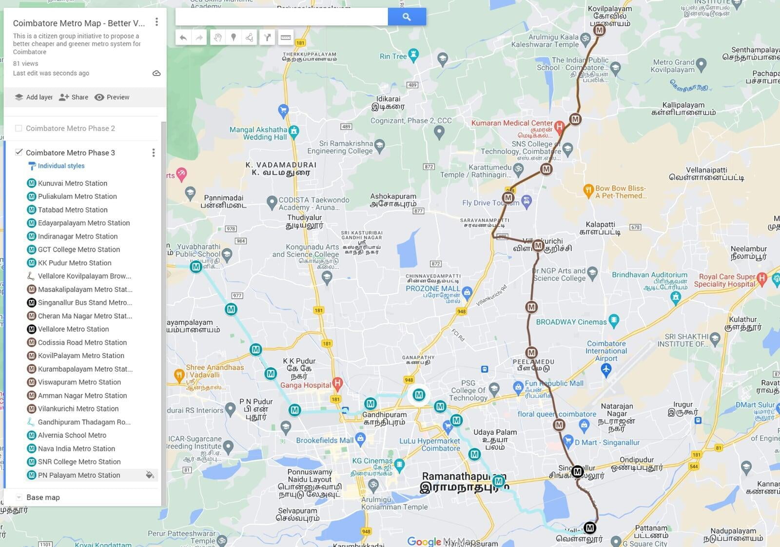
Coimbatore Metro Phase 3 - Connect densely populated areas through non arterial roads
Phase 3 of the Coimbatore Metro system has two lines: the Vellalore to Kovilpalayam Brown line and the Vellalore to Kanuvai Turquoise line. This phase takes a slightly more radical approach to route planning by completely abandoning the hub-and-spoke model, which is usually how metro systems are designed around the world, and instead improves upon our circular model. Just as the City Circular Green line ties Red, Blue, Pink, Purple, and Turquoise lines together, the Brown line plays a similar role by tying in the Pink, Green, Purple, and Blue lines. The Turquoise line does exactly the same by tying in the Green, Red, Pink, Purple, Blue, and finally the Brown line.
It is advisable to adopt a wait-and-watch approach for this phase, monitoring the response and demand on the other phases before embarking on this phase of the project. Unlike Phase 2, this phase only has a small section on the Brown line that traverses through the underdeveloped narrow roads around the Cheran Ma Nagar, Peelamedu, and Vilankurichi areas. The bigger challenges for this route lie around how to navigate the various proposed and under-construction flyovers at Singanallur, Sarvanampatti, and Hopes College. The challenge with the Turquoise line is going to be around convincing all stakeholders about its plan to build on an existing stream, this route attempts something that has never been done anywhere else in the world. Additional question marks that are going to be raised around these proposals are the various misses in the route map, such as not covering some of the popular areas of the city and not having a plan in place for Phase 4 of the Metro, etc.
Here are some ideas that attempt to resolve some of the issues highlighted above:
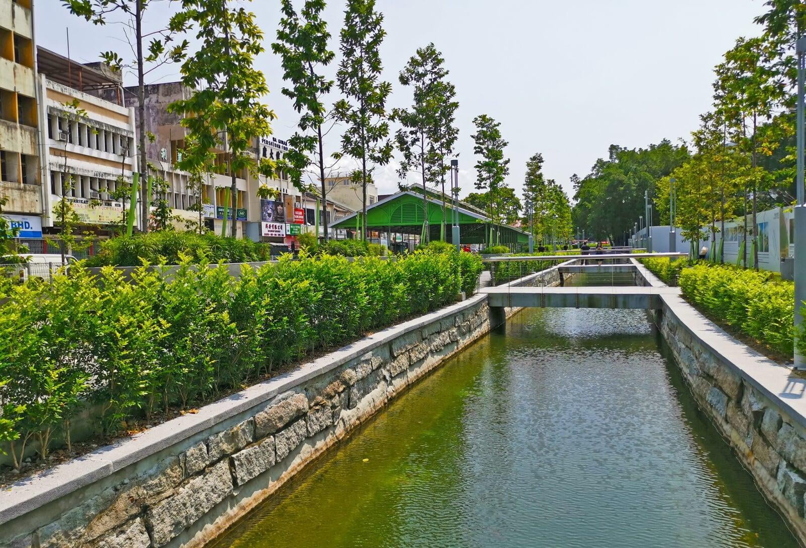
- The Turquoise line: One of our primary goals stated earlier is to bring about positive environmental change and this line will be one of the biggest contributors to achieving the stated goal. Over 50% of the Turquoise line will run right on top of the Sanganoor Stream which amazingly enough cuts right through the middle of the city and goes through some of the most crowded areas. For the last few decades, this stream has been dead and defunct carrying only sewage, garbage and is fully covered with weed growth. This line starts from Kunuvai on Thadagam road comes to Coimbatore North Station and then what might be one of the most radical approaches and probably a world first, it merges fully onto the Sanganoor Stream near Tatabad. For the rest of its route, it traverses exactly on top of the Sanganoor Stream right through the middle of the city connecting every major hub in the city centre. This line is going to be a game changer for the city of Coimbatore for the following reasons:
- The Coimbatore Corporation has been trying to redevelop this stream for many years now but has failed every single time due to lack of funds. The Metro will come with a huge initial budget that will help fund the initial expenditure and once operational there is the income from the Metro that can be used to further revive the stream from source itself.
- This route is perfectly wide enough for a Metro viaduct, it will require no land acquisition, no traffic diversions, no impact on traders and street vendors and in most cases the construction will go on completely un-noticed. Removing the encroachments is the only foreseeable challenge here.
- The trains will run well over 20 feet above the ground level and the metro pillars will be installed on both sides of the stream with strengthen of the bunds using gabion walls or concrete. The floor can be concreted as well (depending on the environmental assessment) to allow smooth water flow from between the pillars.
- The funds from the metro can be used to install low-cost biological water treatment systems along the stream to ensure that the water flowing below is one of the cleanest for an urban waterway system and if planned and executed properly this can become an inland water transport system using gondolas.
- The stations have only been planned at the busiest main road junctions where the Sanganoor stream meets the arterial roads of the city. On the map it might look like the line passes through nowhere but it in fact connects the busiest hubs in the city.
- This development will improve the city's stormwater drainage capacity drastically further improve the inflows into the river Noyyal having a multiplier effect on the city's eco system.
- All profits accrued from the Turquoise line must only be used to improve the waterbodies in and around the city.
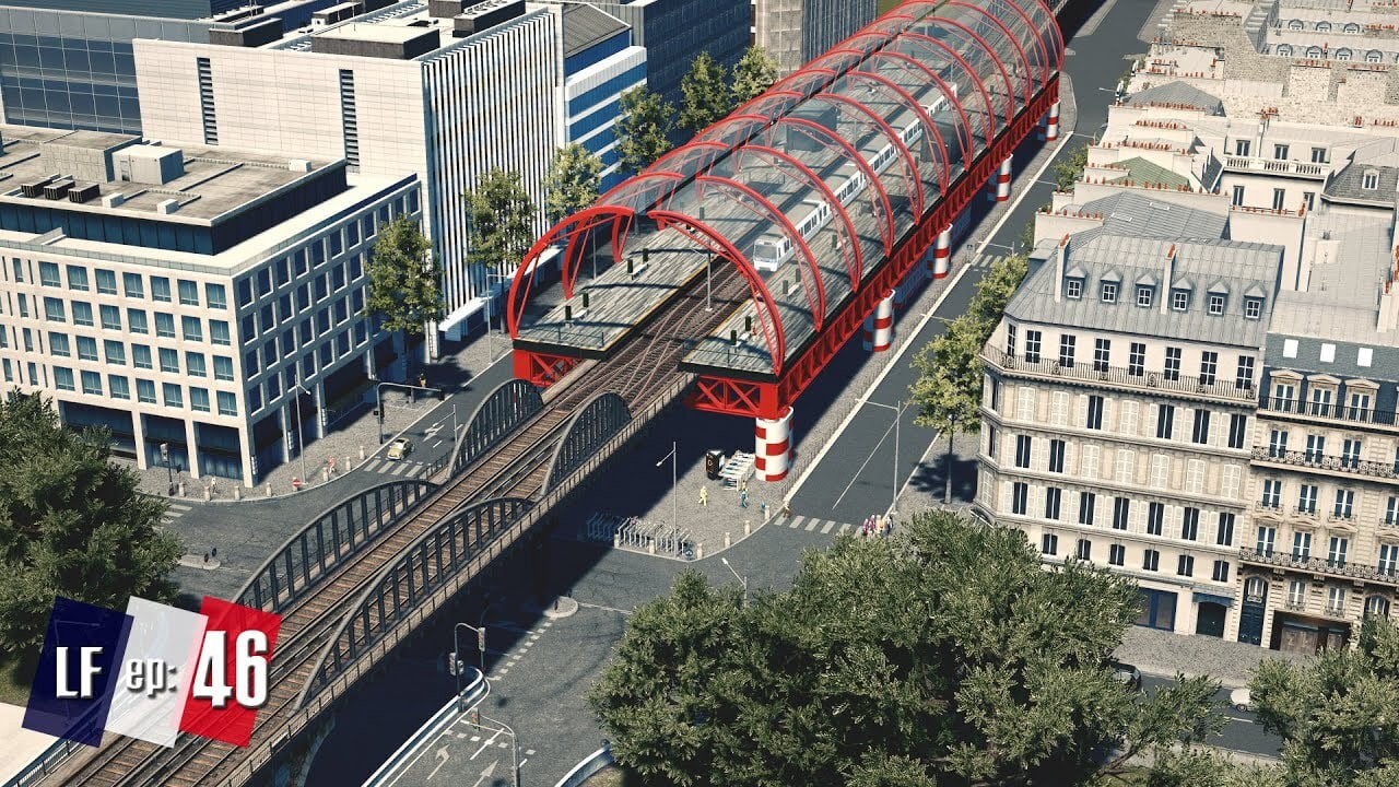
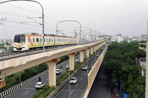
- The Brown Line: This line further extends on to the Sathy Road providing connectivity all the way up to Kovilpalayam as was envisaged in the current metro route map with Sarvanampatti acting as a interchange station between the Pink and Brown lines. This line is critical to the growth of the IT sector in Coimbatore as it connects the Tidal Park with the CHIL and KGISL SEZ along with all the residential areas in between. The challenges posed by the various proposed and under construction flyovers can be resolved through some clever engineering and in some cases by building really tall viaducts that go over and above these flyovers. There is also the option of double decker systems like the one picture from Nagpur Metro below that can be used at the busy junctions like the Singanallur Junction, Hope College Junction and the Saravanampatti Junction.
- Trains, Timing, Ticketing and Initial Infrastructure: Most of these aspects have been elaborated on the Phase 1 plans and the Phase 2 plans so there is not much left to cover on the Phase 3 except for a few misses that have been highlighted below:
- The Nanjundapuram Metro will require additional on ground infrastructure to make it more accessible. The various constraints in the route map have caused it to be located in a fairly undeveloped area.
- Since the Phase 3 is where all the lines have been tied together, the interchange stations will have to be carefully planned such that commuters do not have to walk long distances to change trains.
- Sound barriers will have to be installed at many places on the viaduct as the trains run through busy residential neighbourhoods.
- These lines run through some of the most encroached parts of the city, special attention will have to be given to remove the encroachments in the most humane manner.
Some of the Misses and Maybe a Phase 4?
We acknowledge that no solution is perfect and that our current route map might have missed a few high-density roads like the Palakkad Road, the Muruthamalai Road, areas like R.S Puram and Race Course. But one must also understand that these three Phases of the Metro will take at least 20 years to be fully operational, within that time a lot will change in the way the city moves and the citizen's commute. One example is the upcoming Western Ring Road being built from Mudukarrai on Palakkad Road to Narsimanaickenpalayam on Mettupalayam Road, this might have a great impact on the relevance of Palakkad road as a key artery.
Similarly, our goal is to reduce growth on the Eco Sensitive Western part of the city, that is why no route was planned on Muruthamalai Road and the route was ended as short as Kalampalayam on Perur Road and Kunuvai on Thadagam Road while lines have been extended all the way to Karnampettai and Vellalore on the Eastern and Southern parts of the city.
Cities like Shangahai have over 18 lines of Metro and quite a few other transit options as well, so there is no end to providing connectivity as long as there is demand and off-course the funding. So why stop at Phase 4? There could even be a Phase 5, Phase 6, Phase 7 and so on.
We have spent many hours preparing this report and are happy to spend many more hours improving it by incorporating your feedback from the comments section below. We also have the opportunity to present it in the right channels so do not think your feedback is going to go un-noticed. We urge you to spend some time and give detailed suggestions and justifications for your suggestions in the comments section below. Let's hope the city of Coimbatore that we have come to love in spite of all its shortcomings finds its motivation and transforms the lives of its citizens through a quick, sustainable, equitable and transformative Mass Rapid Transit System.